
Canada is often described through its natural lakes, rivers and vast northern landscapes. Yet some of the country’s largest bodies of water were created not by glaciers or geological forces, but by engineering projects designed to store water and generate electricity. Over the past century, major hydroelectric developments transformed valleys, river systems and low-lying terrain into enormous reservoirs, many of them in remote regions far from major population centres. Several are so large that they rival natural lakes in size and appear as permanent features on modern maps. Together, these reservoirs reveal the scale of Canada’s hydroelectric ambitions and the way energy infrastructure has reshaped parts of the national landscape.According to WorldAtlas, check the list of the 10 largest man-made lakes in Canada.
Top 10 largest man-made lakes in Canada, ranked by surface area

Source: WorldAtlas
Canada’s 10 largest man-made lakes
1. Smallwood Reservoir, Newfoundland and Labrador

pc: worldatlas
Smallwood Reservoir stands as the largest man-made lake in Canada. Located in Labrador, it forms part of the Churchill Falls hydroelectric system, one of the country’s most significant energy projects.What makes the reservoir unusual is that it was not created by a single dam. A network of dikes and control structures altered an extensive area of wetlands, rivers and natural basins, merging them into a vast water storage system. Its sheer scale remains difficult to grasp on the ground, stretching across a landscape where settlements are sparse and distances are immense.2. Caniapiscau Reservoir, Quebec

pc: worldatlas
Northern Quebec is home to several of Canada’s largest reservoirs, and Caniapiscau Reservoir ranks second. Developed as part of the James Bay hydroelectric programme, it serves as a major storage basin within a much larger network of dams and generating stations. The reservoir occupies a remote part of the province where roads are limited, and access can involve long journeys through boreal forest and subarctic terrain. Despite its isolation, it plays a central role in supplying electricity across Quebec.3. Robert-Bourassa Reservoir, Quebec

pc: Worldatlas
Robert-Bourassa Reservoir forms another key component of Quebec’s northern hydroelectric system. The reservoir feeds one of the province’s most important generating complexes. Water stored across this broad expanse can be released as required to support power production, helping balance demand throughout the year. The surrounding landscape is characterised by rocky Canadian Shield terrain, forests and extensive wetlands rather than towns or recreational development.4. La Grande-3 Reservoir, Quebec

pc: worldatlas
La Grande-3 Reservoir occupies a prominent place within the La Grande hydroelectric network. Like many reservoirs in northern Quebec, it exists primarily as a working piece of infrastructure rather than a destination. Seasonal water levels are carefully managed to support electricity generation, with storage capacity helping operators regulate flows through downstream facilities. Seen on a map, its irregular shoreline reflects both the original terrain and the engineering works that transformed it.5. Manicouagan Reservoir, Quebec

pc: worldatlas
Manicouagan Reservoir is perhaps the most visually distinctive entry on the list. Its circular appearance is the result of an ancient meteorite impact that created a massive crater millions of years before the reservoir existed. When water levels rose following the construction of hydroelectric infrastructure, the crater became partially flooded, leaving a ring-shaped lake surrounding a central island. Satellite imagery has made the reservoir one of the most recognisable geographic features in Canada.6. Williston Lake, British Columbia

pc: worldatlas
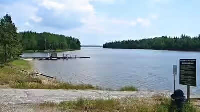
British Columbia’s largest reservoir, Williston Lake, behind the W. A. C. Bennett Dam. The lake stretches through parts of the Rocky Mountain Trench, creating a long and complex shoreline that winds between mountain landscapes and forested valleys. Unlike many eastern reservoirs, its setting is defined by dramatic topography, with surrounding peaks providing a striking backdrop to one of western Canada’s most important hydroelectric assets.7. Lac Seul, Ontario

pc:worldatlas
Ontario’s Lac Seul ranks seventh. The reservoir occupies a region known for its waterways and islands, creating a landscape that feels partly natural and partly engineered. Water levels are managed to support downstream requirements, but the lake has also become associated with outdoor recreation, particularly fishing. Its intricate shoreline gives it a character quite different from some of the larger northern reservoirs.8. Gouin Reservoir, Quebec

pc: worldatlas
Gouin Reservoir sits within central Quebec and has been part of the province’s water management system for more than a century. The reservoir serves multiple purposes, including flow regulation and support for hydroelectric generation further downstream. A maze of inlets, islands and channels creates a highly fragmented shoreline. From above, the reservoir resembles a patchwork of interconnected waterways rather than a single uninterrupted body of water.9. Opinaca Reservoir, Quebec

pc: worldatlas
Opinaca Reservoir forms another link within Quebec’s extensive hydroelectric network. Positioned in a remote northern setting, it works alongside neighbouring reservoirs to regulate water movement through the broader system. Although less well known than some of the province’s larger projects, its role in water storage and flow control makes it an important part of the region’s energy infrastructure.10. Laforge-1 Reservoir, Quebec

pc: worldatlas
Rounding out the list is Laforge-1 Reservoir. Created during the expansion of northern hydroelectric development in the late twentieth century, the reservoir supports power generation through controlled water releases. The surrounding environment remains largely undeveloped, dominated by boreal forest, wetlands and exposed rock formations. Its isolation reflects a pattern shared by many of Canada’s largest reservoirs, which are often located far from the urban centres they help power.